Copper Coast Project
COPPER COAST PROJECT
INTRODUCTION
To align with IGO’s strategic focus on clean energy metals IGO prioritises the exploration of terranes prospective for magmatic nickel sulphide and sediment hosted copper deposits.
The Company has acquired exploration access to extensive belt-scale land positions across Australia, and all are highly prospective for multiple Tier-1 base and precious metals discoveries (Figure 1).
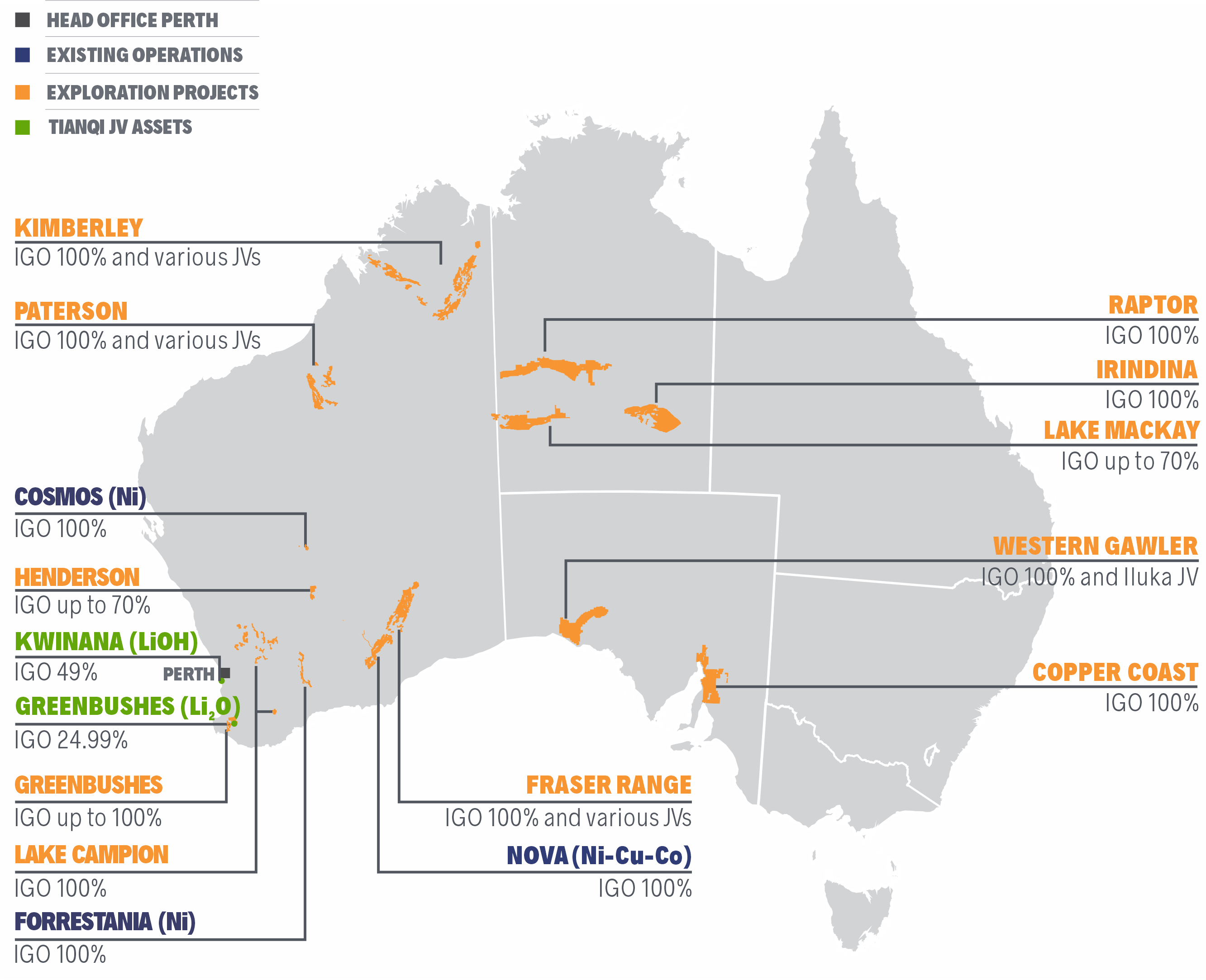
Figure 1 – Location Map of IGO’s Belt-scale Exploration Projects and Operations
TECHNICAL OVERVIEW
The Copper Coast Project is located along the eastern margin of the Gawler Craton in South Australia. West of the Torrens Hinge Zone (THZ), crystalline Paleoproterozoic and Mesoproterozoic basement rocks are known to host IOCG-type mineralisation like Olympic Dam, while to the east the Neoproterozoic sediments of the Adelaide Geosyncline (or ‘Rift’) are prospective for sediment-hosted copper deposits. The Copper Coast Project is a conceptual, model-driven target area that IGO has secured via open staking on a 100% basis. IGO considers the Copper Coast Project represents a significant belt-scale opportunity to find and develop a Tier-1 sediment-hosted copper deposit, similar to the giant Kamoa-Kakula deposit on the margin of the Central African Copperbelt (CACB), which is currently being developed by Ivanhoe Mines.
The Copper Coast Project comprises six granted Exploration Licences (EL 6307 through 6312) covering 4,809km2 and five (soon to be granted) Exploration Licence Applications (ELA’s 2020-66 through 2020-68, ELA 2020-74 and ELA 2020-75) covering 3,456km2.
A review of wide-spaced historical drill holes, most dating back to the 1970’s, has confirmed permissive and prospective stratigraphy that hosts copper mineralisation like that of the CACB. IGO has completed multiple on-ground geophysical surveys on the granted tenements to advance the geological understanding of the project area (Figure 2). Each of these surveys has delivered positive results that support the proposed model, with follow-up exploration planned that will use more advanced exploration techniques (including drilling).
A nominally 1km-spaced, roadside ground gravity survey has confirmed the type of structural and hydrological architecture that is seen in other sediment-hosted copper basins, such as the CACB. The results of a regional magneto-telluric (MT) geophysical survey, which was cut short by the COVID-19 pandemic, appears to corroborate the new gravity data, but additional work is required to validate the results. Several historic drill holes have recently been selected and submitted for HyLogger spectral scanning to identify and map any alteration that may be related to ore-forming processes. A three-hole stratigraphic diamond drilling program is planned for execution during Q3FY21 to test and validate the geophysical work completed to date. Positive results from the 2021 drilling program will progress the project to a further round of target generation and drill testing.
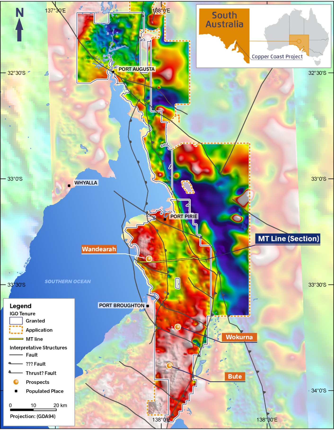
Figure 2 - Copper Coast Project showing drilling prospects plotted on a map of the basin-margin structural architecture interpretation, which is draped over the Bouguer gravity intensity image
 IGO Copper Coast Project


 MAKING A